
From the Open-Publishing Calendar
From the Open-Publishing Newswire
Indybay Feature
Tropical storm Maria nears hurricane strength
Tropical storm Maria was gathering energy from warm ocean water but remained over the open Atlantic on Saturday and posed no immediate threat to land.
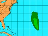
Tropical Storm Maria as of 8 a.m. Saturday (National Hurricane Center)
"Some strengthening is forecast ... and Maria could be near hurricane strength by Sunday,'' said Jack Beven, a hurricane specialist at the U.S. National Hurricane Center in Miami.
At 5 a.m. EDT the storm had maximum sustained wind of 80 kilometres an hour and was centred 1,255 kilometres east-northeast of the northern Leeward Islands, about 1,570 kilometres southeast of Bermuda.
It was moving northwest, a track that could take it east of Bermuda, at 21 km/h, forecasters said.
Maria is the 13th named storm of the Atlantic hurricane season, one of the busiest on record. Historically, only about four or five named storms form by this time of year, according to the hurricane centre.
If the storm's sustained wind speed reaches 119 km/h as expected, Maria would be the season's fifth hurricane.
The Atlantic hurricane season begins June 1 and ends Nov. 30. Peak storm activity typically occurs from the end of August through mid-September
http://www.ctv.ca/servlet/ArticleNews/story/CTVNews/1125758058185_121167258/?hub=World
Vigorous wave well out in the Atlantic could become 2005's fifth hurricane
The 2005 hurricane season has moved into primetime over the the Atlantic Basin--the region encompassing the Atlantic, Caribbean and Gulf of Mexico. Forecasters are carefully monitoring a series of disturbances which have emerged from Africa in recent days. One "wave" churning west from a position halfway between the eastern Caribbean and the African coast late Thursday, could, if several computer projections verify, intensify to a hurricane this weekend.
http://www.chicagotribune.com/news/local/chi-0509020015sep02,1,5197760.column?coll=chi-news-hed
We are 100% volunteer and depend on your participation to sustain our efforts!
Donate

$230.00 donated
in the past month
Get Involved
If you'd like to help with maintaining or developing the website, contact us.
Publish
Publish your stories and upcoming events on Indybay.
Topics
More
Search Indybay's Archives
Advanced Search
►
▼
IMC Network
"We're not out of the woods yet," said Susan Cutter, director of the University of South Carolina Hazards Research Laboratory. "We're not even in the height of hurricane season."
A forecast released Friday by meteorologists at Colorado State University calls for six more hurricanes by the time the hurricane season ends on Nov. 30, three of them Category 3 or above. On average, about one major hurricane in three makes landfall in the United States.
"We expect that by the time the 2005 hurricane season is over, we will witness tropical cyclone activity at near record levels," the Colorado State meteorologists wrote.
So far there have been four hurricanes this year _ Katrina, Irene, Emily and Dennis, a Category 3 storm that caused more than $1 billion in damage to the Florida panhandle in July. There have been nine tropical storms.
That puts this season's tropical cyclone activity to date above the average for an entire year, the Colorado State forecast noted. In a more normal year, Mother Nature has produced about a third of her annual allotment of hurricanes and tropical storms by this point in the season.
No major storms currently threaten the U.S. coastline. The latest report from the National Weather Service mentions only Tropical Storm Maria.
"Maria could be near hurricane strength by Sunday," said Jack Beven, a meteorologist at the National Hurricane Center in Miami.
The storm is not currently expected to reach the U.S. mainland.
The number and intensity of hurricanes is largely determined by water temperatures at the sea surface. This year the waters of the tropical Atlantic, Caribbean and Gulf of Mexico are about as warm as they ever get.
If a major hurricane were to make landfall somewhere on the U.S. coast in the next two months, with the situation in Louisiana and Mississippi still demanding such a large portion of the nation's emergency management resources, mounting another relief effort would certainly be more difficult than usual. But as Florida demonstrated when four hurricanes passed through the state in seven weeks last year, repeated storms are not necessarily unmanageable.
"It would be a challenge, but I don't think it would be catastrophic," Cutter said.
And in many respects another hurricane in the area already devastated by Katrina would only add insult to injury.
"It sounds horrible, but it may not be that bad," Cutter said. "The sad thing is that most of the damage has already been done."
But in New Orleans itself, any violent weather threatens to expand the gaping holes that Katrina opened in the city's flood control infrastructure.
"Even a tropical storm I think would wreak havoc," said Joannes Westerink, a civil engineer at the University of Notre Dame who produces computer simulations of storm surges for the U.S. Army Corps of Engineers, the Federal Emergency Management Agency and other clients.
Even the daily tidal flows of Lake Pontchartrain threaten to aggravate the conditions left by Hurricane Katrina, he said.
Westerink said he and his colleagues have started working on simulations depicting the effects of a hurricane on the New Orleans levee system in its current state. They expect to have a complete picture in a few days of what another hurricane could do to the city.
New Orleans also remains vulnerable to a Mississippi River flood brought on by heavy rains upstream. But the usual flooding season for the river is spring and early summer.
http://itemonline.com/articles/2005/09/03/ap/headlines/d8cd5o900.txt